
From Egypt to the Promised Land
PEOPLE everywhere know of the Exodus from Egypt. But what awaited Moses and God’s people after they crossed the Red Sea? Where did they head, and how did they reach the Jordan River to enter the Promised Land?
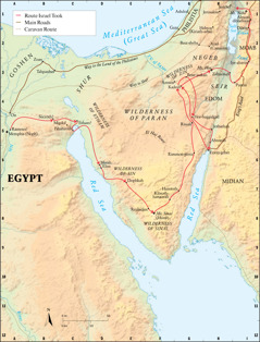
Their goal was the land of Canaan, yet Moses did not take the shortest route—about 250 miles (400 km) along the sandy coast—which would have led straight through Philistia, enemy territory. Nor did he head across the vast center of the Sinai Peninsula, where intense heat baked the gravel and limestone plateau. No, Moses led the people south, down the narrow coastal plain. The first camp was at Marah, where Jehovah made bitter water turn sweet. a After leaving Elim, the people murmured for food; God sent quail and then manna. At Rephidim, water was again an issue, attacking Amalekites were vanquished, and Moses’ father-in-law urged him to get help from capable men.—Ex, chaps. 15-18.
Moses then led Israel toward the mountains farther south, camping at Mount Sinai. There God’s people received the Law, built the tabernacle, and offered sacrifices. In the second year, they went north through a “great and fear-inspiring wilderness,” the journey to the area of Kadesh (Kadesh-barnea) apparently taking 11 days. (De 1:1, 2, 19; 8:15) Because of becoming fearful over a negative report from ten spies, the people had to wander for 38 years. (Nu 13:1–14:34) Among their stops were Abronah and Ezion-geber, and then they went back to Kadesh.—Nu 33:33-36.
When it was finally time for Israel to approach the Promised Land, the Israelites did not move due north. Their route took them around Edom’s heartland and up “the king’s road,” the King’s Highway. (Nu 21:22; De 2:1-8) It was not easy for a whole nation—with children, animals, and tents—to move over this trail. They had to wind down into and climb back out of formidable gorges—the Zered and the Arnon (nearly 1,700 feet (520 m) deep).—De 2:13, 14, 24.
Finally, the Israelites reached Mount Nebo. Miriam had died at Kadesh, and Aaron, at Mount Hor. Moses now died in sight of the land he had desired to enter. (De 32:48-52; 34:1-5) It fell to Joshua to lead Israel into the land, ending a journey begun 40 years earlier.—Jos 1:1-4.
[Footnote]
a The exact location of most encampments is not known.
[Map on page 9]
(For fully formatted text, see publication)
Exodus Route
Route Israel Took
A7 EGYPT
A5 Rameses?
B5 Succoth?
C5 Etham?
C5 Pihahiroth
D6 Marah
D6 Elim
E6 WILDERNESS OF SIN
E7 Dophkah
F8 Rephidim
F8 Mt. Sinai (Horeb)
F8 WILDERNESS OF SINAI
F7 Kibroth-hattaavah
G7 Hazeroth
G6 Rimmon-perez
G5 Rissah
G3 Kadesh
G3 Bene-jaakan
G5 Hor-haggidgad
H5 Jotbathah
H5 Abronah
H6 Ezion-geber
G3 Kadesh
G3 WILDERNESS OF ZIN
H3 Mt. Hor
H3 Zalmonah
I3 Punon
I3 Iye-abarim
I2 MOAB
I1 Dibon
I1 Almon-diblathaim
H1 Jericho
[Other locations]
A3 GOSHEN
A4 On
A5 Memphis (Noph)
B3 Zoan
B3 Tahpanhes
C5 Migdol
D3 SHUR
D5 WILDERNESS OF ETHAM
F5 WILDERNESS OF PARAN
G1 PHILISTIA
G1 Ashdod
G2 Gaza
G2 Beer-sheba
G3 Azmon
G3 NEGEB
H1 Jerusalem
H1 Hebron (Kiriath-arba)
H2 Arad (Canaanite)
H4 SEIR
H4 EDOM
I7 MIDIAN
Main Roads
Way to the Land of the Philistines
Way to Shur
I4 King’s Road
Caravan Route
El Haj Route
[Mountains]
F8 Mt. Sinai (Horeb)
H3 Mt. Hor
I1 Mt. Nebo
[Bodies of water]
E2 Mediterranean Sea (Great Sea)
D7/G7 Red Sea
I1 Salt Sea
[Rivers and streams]
A6 Nile River
F3 T.V. of Egypt
I2 Arnon
I3 Zered
[Picture on page 8]
Caravans crossed the Sinai Peninsula
[Picture on page 8]
Israel camped before Mount Sinai
[Picture on page 9]
Water was available from springs at or near Kadesh
[Picture on page 9]
All Israel had to traverse the torrent valley of Arnon