
Israel in the Days of David and Solomon
GOD promised to give Abram’s seed the land “from the river of Egypt to . . . the river Euphrates.” (Ge 15:18; Ex 23:31; De 1:7, 8; 11:24) After Joshua entered Canaan, it was some four centuries before the Promised Land reached those limits.
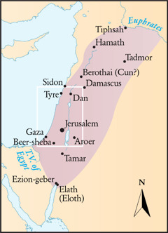
King David overthrew the Aramaean kingdom of Zobah, which reached the Euphrates in northern Syria. a To the south, David’s success against the Philistines brought him to Egypt’s border.—2Sa 8:3; 1Ch 18:1-3; 20:4-8; 2Ch 9:26.
Solomon then ruled “from the River [Euphrates] to the land of the Philistines and to the boundary of Egypt,” foreshadowing the Messiah’s peaceful rule. (1Ki 4:21-25; 8:65; 1Ch 13:5; Ps 72:8; Zec 9:10) Still, the area that Israel occupied was normally said to extend “from Dan to Beer-sheba.”—2Sa 3:10; 2Ch 30:5.
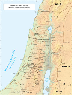
Disobeying God, King Solomon accumulated horses and chariots. (De 17:16; 2Ch 9:25) He could move these over a network of roads and highways. (Jos 2:22; 1Ki 11:29; Isa 7:3; Mt 8:28) We have a detailed route of only a few of these, such as “the highway that goes up from Bethel to Shechem and toward the south of Lebonah.”—Jg 5:6; 21:19.
The Roads and Highways of Ancient Israel notes: “The most obvious difficulty in investigating ancient Israel’s road network is the fact that no clearly identifiable physical traces of the country’s roads from the Old Testament period have survived, because roads were not paved during [that period].” Yet, topography and the excavated remains of cities indicate the course of many of the roads.
Roads often influenced troop movements. (1Sa 13:17, 18; 2Ki 3:5-8) To attack Israel, the Philistines marched from Ekron and Gath to the area “between Socoh and Azekah.” Saul’s army met them there “in the low plain of Elah.” After David slew Goliath, the Philistines fled back to Gath and Ekron, and David went up to Jerusalem.—1Sa 17:1-54.
Lachish (D10), Azekah (D9), and Beth-shemesh (D9) sat astride natural routes through the Shephelah and toward the Judean hills. Thus these cities were keys to blocking enemies on the Via Maris from coming into Israel’s heartland.—1Sa 6:9, 12; 2Ki 18:13-17.
[Footnote]
a Reubenite territory reached into the Syrian Desert, the eastern edge of which was the Euphrates.—1Ch 5:9, 10.
[Maps on page 17]
(For fully formatted text, see publication)
Territory and Roads During United Monarchy
Boundaries (Solomon’s time)
Tiphsah
Hamath
Tadmor
Berothai (Cun?)
Sidon
Damascus
Tyre
Dan
Jerusalem
Gaza
Aroer
Beer-sheba
Tamar
Ezion-geber
Elath (Eloth)
[Rivers and streams]
Euphrates
T.V. of Egypt
David and Solomon (roads)
B10 Gaza
C8 Joppa
C9 Ashdod
C10 Ashkelon
C11 Ziklag
C12 WILDERNESS OF PARAN
D5 Dor
D6 Hepher
D8 Aphek
D8 Ramah
D9 Shaalbim
D9 Gezer
D9 Makaz
D9 Ekron
D9 Beth-shemesh
D9 Gath
D9 Azekah
D10 Soco(h)
D10 Adullam
D10 Keilah
D10 Lachish
D11 Jattir
D12 Beer-sheba
E2 Tyre
E4 Cabul
E5 Jokneam (Jokmeam?)
E5 Megiddo
E6 Taanach
E6 Arubboth
E7 Pirathon
E8 Lebonah
E8 Zeredah
E8 Bethel
E9 Lower Beth-horon
E9 Upper Beth-horon
E9 Geba
E9 Gibeon
E9 Gibeah
E9 Kiriath-jearim
E9 Nob
E9 Baal-perazim
E9 Jerusalem
E9 Bethlehem
E10 Tekoa
E10 Hebron
E11 Ziph
E11 Horesh?
E11 Carmel
E11 Maon
E11 Eshtemoa
F5 En-dor
F5 Shunem
F5 Jezreel
F6 Beth-shean
F7 Tirzah
F7 Shechem
F8 Zarethan
F8 Shiloh
F8 Ophrah?
F9 Jericho
F11 En-gedi
G2 Abel-beth-maacah
G2 Dan
G3 Hazor
G3 MAACAH
G5 Lo-debar (Debir)
G5 Rogelim
G6 Abel-meholah
G7 Succoth
G7 Mahanaim
H1 SYRIA
H4 GESHUR
H6 Ramoth-gilead
H8 Rabbah
H9 Medeba
H11 Aroer
H12 MOAB
I4 Helam?
I9 AMMON
[Main Roads]
C10 Via Maris
H6 King’s Road
[Mountains]
F5 Mt. Gilboa
[Bodies of water]
C8 Mediterranean Sea (Great Sea)
F10 Salt Sea (Dead Sea)
G4 Sea of Galilee
[Spring or well]
E9 En-rogel
[Pictures on page 16]
Right: Valley of Elah, looking eastward to the hills of Judah
Below: A network of roads permitted travel in the Promised Land